Monthly Archives: November 2019

Historic maps

These maps are taken from the archive of Ordnance Survey maps held at the National Library of Scotland. They chart the gradual development of the area.

fullsizeoutput_a1fd

fullsizeoutput_8961

fullsizeoutput_8960

fullsizeoutput_8963

fullsizeoutput_895f

fullsizeoutput_8965

fullsizeoutput_a0be

Enter a caption

This is an image from Google Earth taken in 1945. It shows the allotments having spilled over into the area now occupied by the student flats, as well as a significant area of the golf course. This is part of the “Dig for Victory” campaign of the Second World War.

fullsizeoutput_a0bd

Enter a caption

This wider image shows the whole of Florence Park being under cultivation.

Advertisement

Photographs from the distant past

These are photographs taken by Henry Taunt (1842 – 1922). He began taking photographs in 1860. He travelled widely through the county, and beyond to neighbouring counties and to London. In 1889 he rented out Canterbury House (which he later re-named Riviera) and built a workshop at the back of the property. The house is on Cowley Road, just south of the Glanville Road junction, and has a blue plaque commemorating Taunt’s time there.

These are a few of the hundreds of images of Taunt’s photographs on the Historic England website; they are also available, including as high density images, at Oxfordshire History Centre and other County libraries

With 14000 images surviving there are many of the area around his home.

Version 3

Possibly Taunt’s best-known picture. Children playing ducks and drakes; in an old sheep wash at Barracks Lane, Cowley Marsh, in July 1914 (a month before the start of the First World War). East Oxford had been developed from fields into a suburb since the 1850s and this stream now formed part of the city boundary. These are two of relatively few photographs where children appear as the subject rather than as a decoration or added interest. In the background are men in military uniform playing golf.

fullsizeoutput_a185

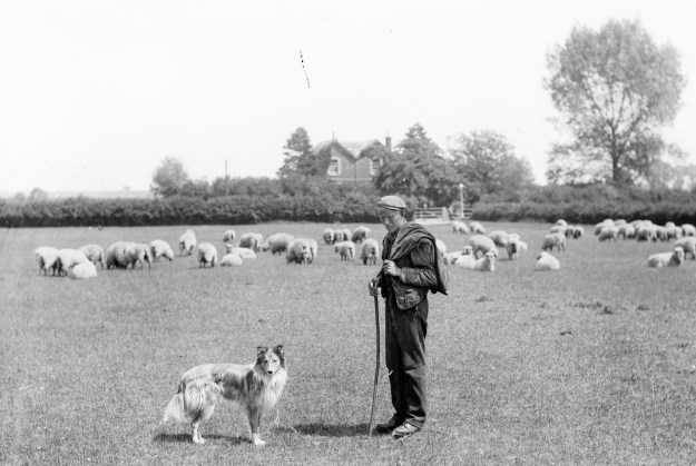
The shepherd and his dog standing in a field opposite Riviera, the home of Henry Taunt. The sheep are standing where the Regal Community Centre now stands.


fullsizeoutput_a186

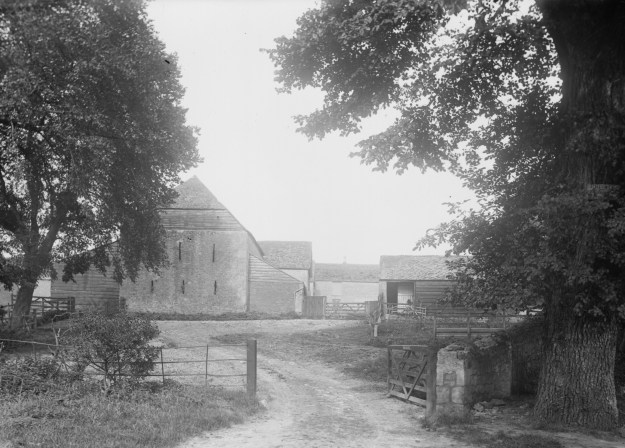
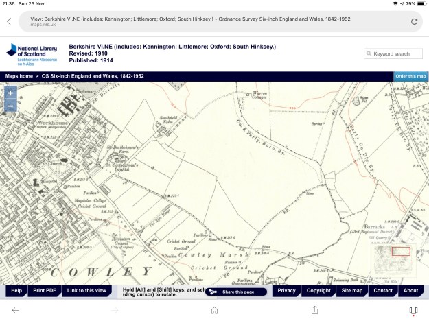
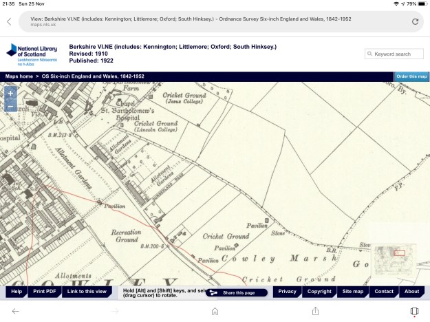
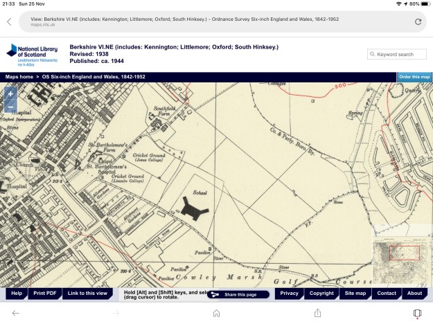
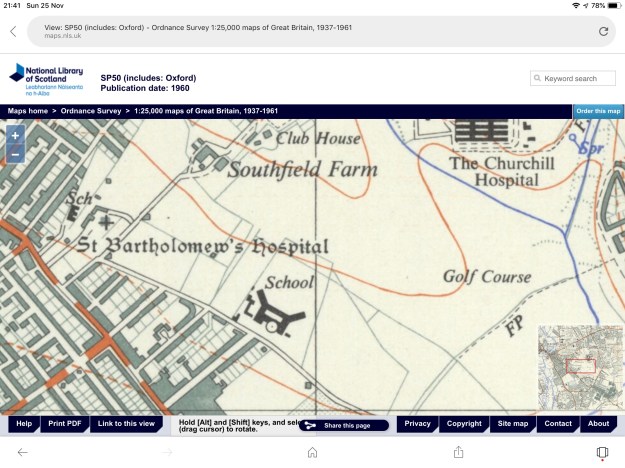
Southfield Farm. Looking into the farmyard through an opened gate toward a stone barn with a weatherboard and tiled hipped roof with outbuildings attached. This is where Southfield flats are now situated.


fullsizeoutput_a187

Looking towards the Cowley Road from Taunt’s house


fullsizeoutput_a188

Looking across from the tower of St Kenelm”s Church, Cowley, with open fields between Cowley and the city.


fullsizeoutput_a189

Henry Taunt outside his home. He rented this house Canterbury House in 1889, later changing its name to Riviera. Notice also a man on a very long ladder leaning against the house.


fullsizeoutput_a18a

The Boundary stone on Cowley Marsh, with golfers in the distance


fullsizeoutput_a18c

Distant view of Cowley from Lye Hill looking down to the stile.


fullsizeoutput_a18d

A view of Cowley Road towards Riviera, featuring a man with a pram, and a man with a milk churn.


fullsizeoutput_a18e

A view towards Cowley


fullsizeoutput_a18f

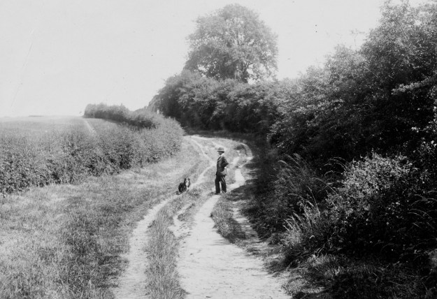
Barracks Lane, Cowley, Oxford, Oxfordshire. A gentleman and is dog standing on the country lane outside Cowley. The barracks of the 43rd and 52nd Foot Regiments of the Oxfordshire and Buckingham Light Infantry, after which the lane was named, nearby in 1877.


fullsizeoutput_a190

Barracks Lane, Cowley, Oxford, Oxfordshire. Sergeant Major Jacobs standing next to a ditch running alongside Barracks Lane in Cowley. The barracks were built in 1877 for the 43rd and 52nd Foot Regiment of the Oxfordshire and Buckinghamshire Light who resided there until 1952.


fullsizeoutput_a191

View of the rear of Taunt’s house Riviera. The photographer would have been sited near to Barracks Lane.


fullsizeoutput_a192

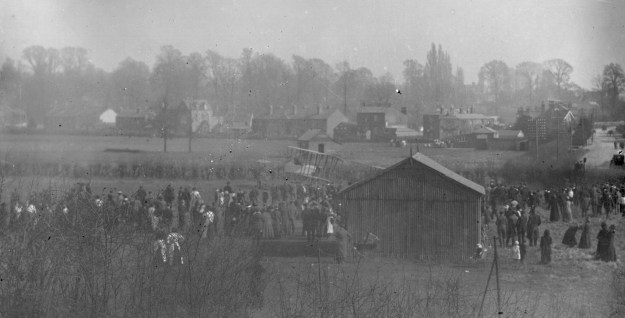
A large group of people gather around a biplane that had landed on land near what is now Cowley Marsh playing fields.


fullsizeoutput_a193

Taken from Lye Hill looking towards the Barracks.


fullsizeoutput_a194

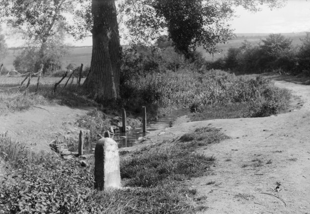
Barracks Lane, Cowley, Oxford, Oxfordshire. Looking west down a grassy path near the barracks, with a stone marker and benchmark on the right.


fullsizeoutput_a195

A view  of the Cowley Road Hospital; it was built in 1863-5 as the Oxford City Workhouse, designed to hold 330 inhabitants. It was taken over during the First World War for the treatment of war casualties. It was closed in 1981 and has since been demolished.

fullsizeoutput_a196

Barracks Lane, Cowley, Oxford, Oxfordshire. Looking up the lane, towards a woman,  from the bottom of Sand Hill.


fullsizeoutput_a197

View of the pool or stream used for sheep washing


fullsizeoutput_a199

View from SS Mary and John Church tower looking toward the city


Progress on the polytunnel 18th November 2019

Many thanks to a band of helpers who were able to line the sides of the polytunnel with wood chippings. The group included Liz, Pam, Stephen, Dave, Rebecca, Christine and James. 

We have another much larger pile of wood chippings; these are going to cover the picnic area at the top of the hill.

IMG_3720

Wood chippings now surround the polytunnel

IMG_3719

A group of wise heads considering the next steps with the polytunnel


A Growing Concern

As part of their 100th anniversary celebrations The Oxford and District Federation of Allotment Associations have published a book entitled “A Growing Concern. It is available from the Museum shop in the Town Hall, priced £6.00

IMG_3600

Its authors Phil Baker and Wendy Skinner Smith draw on contributions from the constituent associations; our own Stephen Pegg wrote in the book this piece about Barracks Lane.

BARRACKS LANE ALLOTMENTS

Both fields of BLA have been sites of activity since ancient times, with a Roman pottery kiln on the boundary to the east and a late medieval quarry a stone’s throw to the south. The heavy clay, sandier in some areas, has been cultivated or used as a hayfield for centuries; two undated aerial photos show allotment plots extending north up on to what is now the Golf Club and south on to The Spires playing fields, probably because of wartime requirements. Links Allotments (as we were originally called) came into being during World War II then split from Bartlemas Close in 2012, later to create its own constitution and new name.

It is a pleasant very open site of about 4.5 acres and, with college woods, school playing fields and a golf course on three sides, has a rural feel, especially with regard to voracious muntjac, vandalous badgers and the strange scream of vixens late dusk. From a perusal of the records, it is clear that demographics have changed greatly : we now have more single persons, women, young married couples and plots shared by Associate Members. Some changes reflect a general reorientation of allotments to their community – we regularly welcome young children from a local school into a thinly–wooded area set aside for them. Cultivation techniques range from fluttering miles of Mypex to altitudinous raised beds (a 1:15 slope means bottom plots can get very wet after storms).

Following some years of inertia, we are now enjoying a very active period; there is a waiting list and our five or so working parties a year get ‘stuck in’. Projects for this year include a recreational seating area and…The Polytunnel. Standards are high –  though not as demanding as in the 50’s and 60’s when meeting minutes mention posses of committee members visiting prospective allottees at home to inspect the state of their gardens! Notes from other meetings include : (1945) Chairman’s pears have been pilfered (1970) Mr and Mrs F. (who now have the neatest plot on site) sent a stern letter (1985) Mr H. has been found sleeping in his shed again (1990) Committee is not sure whether M. is allowed her geese.

Both ‘A’ and ‘B’ Fields are rich in memories, most of which are passed on between moans about the weather and a cup of tea. The Shed, for example, a big breeze-block affair of the 60’s which stored everything and up to 20 years ago featured the shop selling potatoes, onion sets and bagged-up chemicals (thankfully replaced by organics, bar the odd sprinkle of Growmore) now replaced by The Container, painted a nice shade of woodland green. Some plotholders live on in the folklore: Mary S., who famously found uses for vast quantities of black knicker-elastic (still being dug up) in all her allotment activities; Margaret C., whose love of animals drove her to distraction when a member chased a pheasant intending to impale it with his fork. M.’s sympathies were with the bird. She pursued the Greek gentleman all round the field threatening him with hers. A policeman had to be summoned to convince M. of the ill-advised nature of homicide.

Remembering and celebrating a tradition of cultivation in this place, we look forward to continuing our stewardship.